Over the course of 22 days in 2016 and 1 in 2017, I backpacked the entirety of the John Muir Trail in the Sierra Nevada Mountains of California. The life marking experience was recorded in my daily journal entries and this short film. Below are the entries along with information about each day’s journey produced at caltopo.com.
The John Muir Trail – Day-by-Day Journal Entries
Day 1: Happy Isles to Sunrise Creek
Brekkie at Yosemite Lodge after fixing permit back to 2. Steve came to Vernal Bridge. Lots of uphill for me all day. Around lunch, met Josh from Nashville on trail. Reporter. Young guy. We had lunch and chatted along river above Nevada Falls. We split at Little Yosemite Valley because I had to camp 2 mi further on JMT. Maybe see him at Cathedral. Slog to get to camp. Found site near Sunrise Creek. Group of ~6 guys right nearby. Did laundry. Bathed. Ate. Ready for nap before dinner. Slept for a few. Dinner. Make friends with neighboring campers (4 guys from LA doing a 4 day wander). In bed ~930/45. Animals around 1:30. Bear can knocked over. Thinking I want to always camp near others.
Day 1 Map

Day 1 Profile
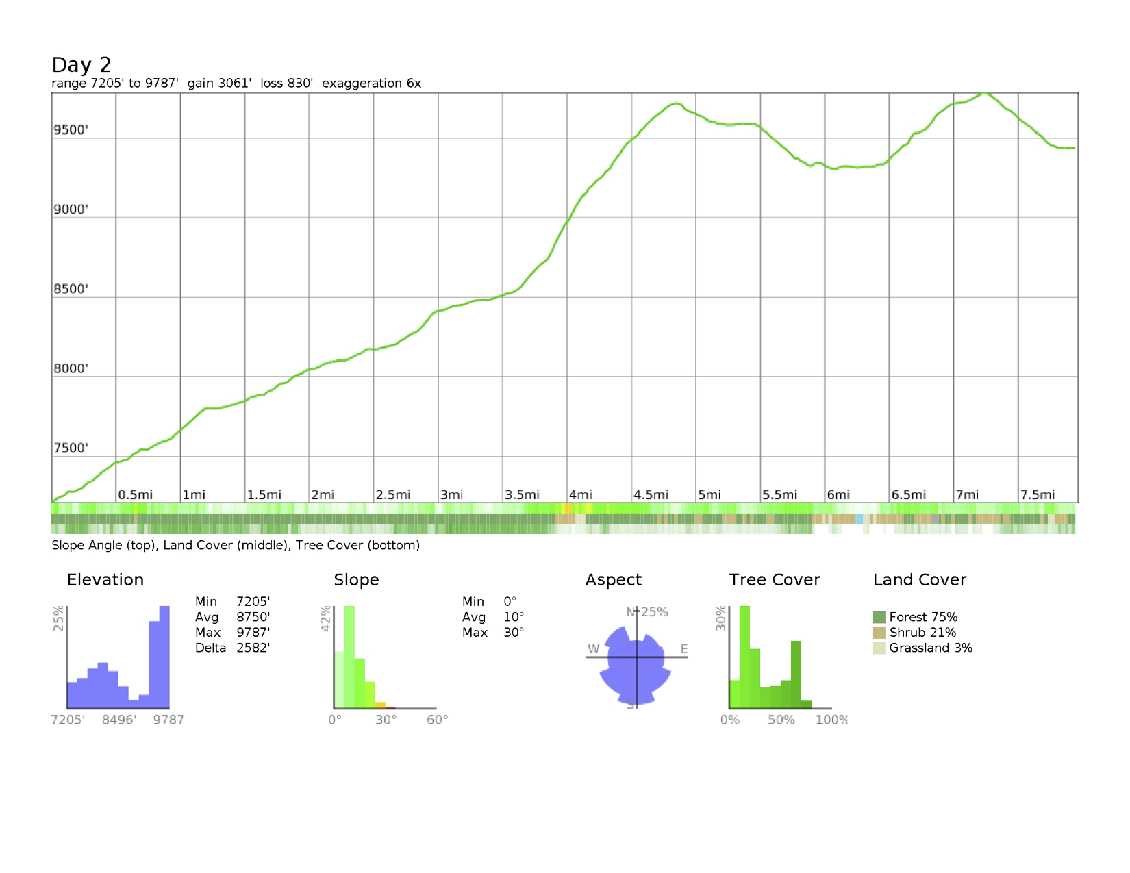
 Day 2: Sunrise Creek to Sunrise Lakes
I notice a delirium sets in once I set up camp, do laundry and lay down. It’s a pleasurable one actually. There is also a strange sense of wildness growing in me – and it’s only Day 2! Sort of like freedom but burly. I like it. I’m eager to see where this goes. Today was Sunrise and on the way, I bumped into Ranger James McGrew. Then onto Sunrise where I got free lemonade, a nectarine, and candy. I’m really paying attention to my salts and have Nuuns as needed. So far, so good. But the M & M’s were nice. I decided to come to Sunrise Lakes to camp as the High Sierra Camp was dry. I’ll pay for it tomorrow as I have an uphill climb and an extra 1.5 mi. I spent some time on my JMT app laying out routes to Mammoth. There’s some long days ahead and I’ll have to rest tomorrow at Cathedral Lake to be ready for the next 2 days. It’s dinnertime now.
Now watching the sunset on the first full self-supported day over a ridge. Birds and chipmunks chatter. Airplanes rumble above. Light touch of a breeze. Amazing beauty. I think I hear cars on 120 in the distance. But now I’m tired. I want to stay up to see the stars but I have small motivation. Stillness is bathing me.
Day 2 Map
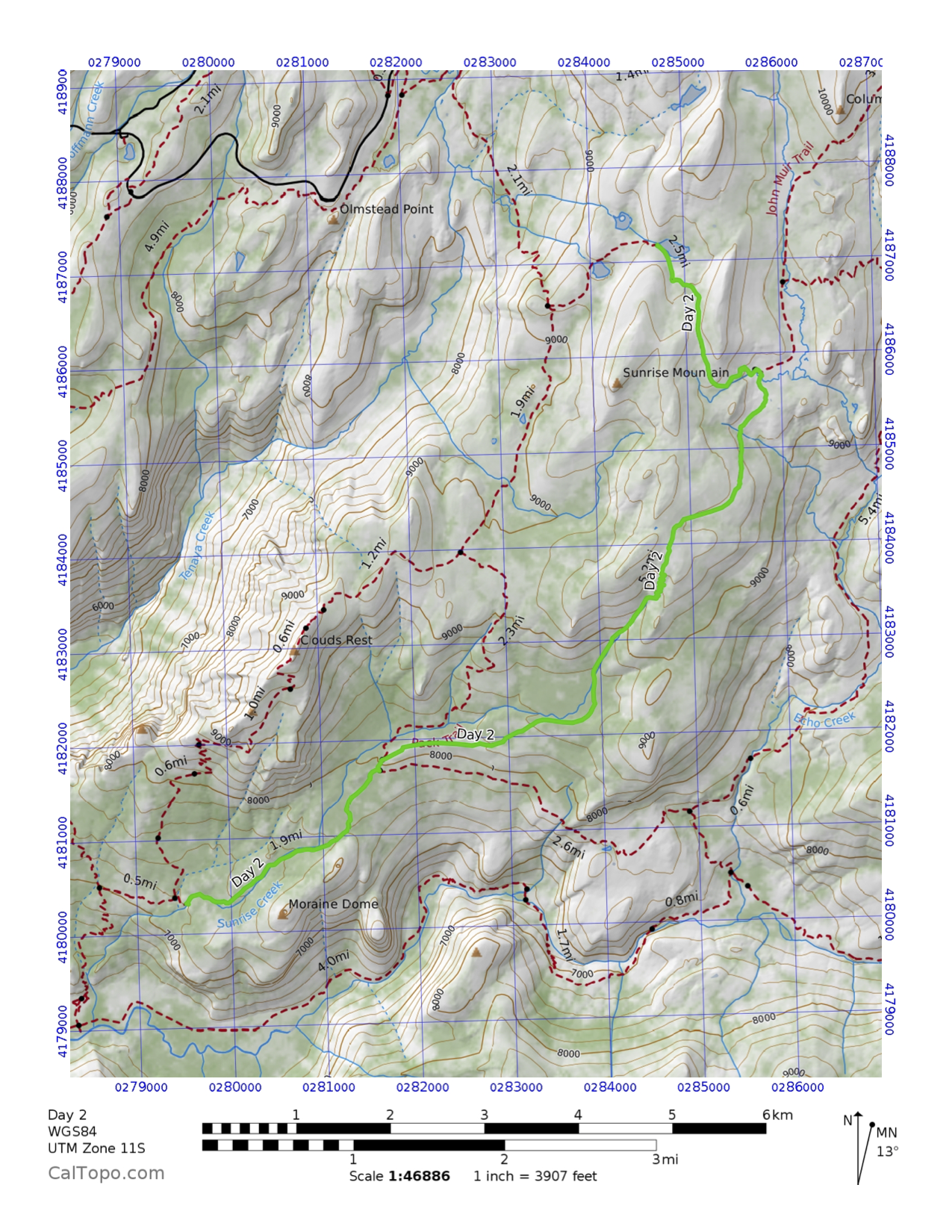
Day 2 Profile
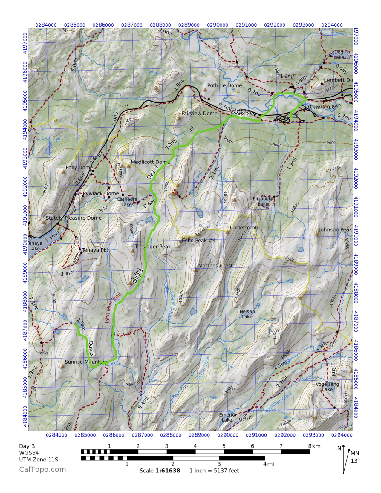
 Day 3: Sunrise Lakes to Tuolumne Meadows Campground
Thundering and wind and clouds roiling the sky outside my tent here in Tuolumne Meadows backpacker campground. I took my rest day and pushed all the way here from Sunrise to stage better for Donahue, especially with weather changing things. I’m so happy I did because I had food at the grill (after not having the correct brekkie), talked with Kathi and texted with Peter. Still darn beat even after the food and will still make dinner in a few. Today was generally easy and ended with a long wash down in the Tuolumne River. I picked up my resupply and have a full bucket now. Should be interesting tomorrow! I met some JMTers but not much socializing going on yet. Probably because I’m too tired! Went to the ranger talk – it was about bears. Meh. I’ve redone my plans over the next days and am much more relaxed now. This has been an interesting interlude today here where my Yosemite love began.
Day 3 Map
Day 3 Profile
 Day 4: Tuolumne Meadows Campground to Lyell Forks
Admittedly this was even more than I expected – and I’m super happy I pushed it. Camping with at least 6 other JMTers. But I also realize that as cohorts move along at different paces, not every one sticks together. For some reason, I just never even thought about that or that I’d be somewhat bummed! I suppose bonding with someone or ones can’t happen in a single or two-day window together. Who knows – maybe there will be other lazy folks. I feel like I could do 9-10 miles a day but I’m around 6-8 until Mammoth. Perhaps I should slow down. Smoking along at this rate would get me to Whitney 6 days earlier! Lyell Canyon and valley were stunning today. Gorgeous river meanders among verdant meadows. Canyon ridges of white and gray granite keeping sentinel on the bucolic scene. It was flat and wet until a climb up to Lyell Forks and the bottom of Donahue Pass. That sucked. Then arriving at the footbridge and sprinkles starting, necessitating a quick tent up only to have the clouds disappear. But up here where the waters converge is just paradise. I did real laundry, splashed in the cold water and made pals with Mike from LA, Liza from Boston, and Jon from Berkeley (Mike and I met on the trail today). I thought about Dad a bit today on the trail. The scene from “Wild” when she screams into the air about her mom kinda resonated and I guess I don’t have any more anger about him dying. I miss him though, just not in the intense way I used to but more in a kinder way. I also realized again that I finished my PhD. I teared up over that.
Day 4 Map
 Day 4 Profile
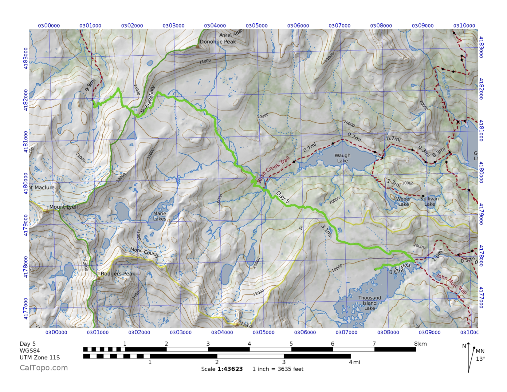
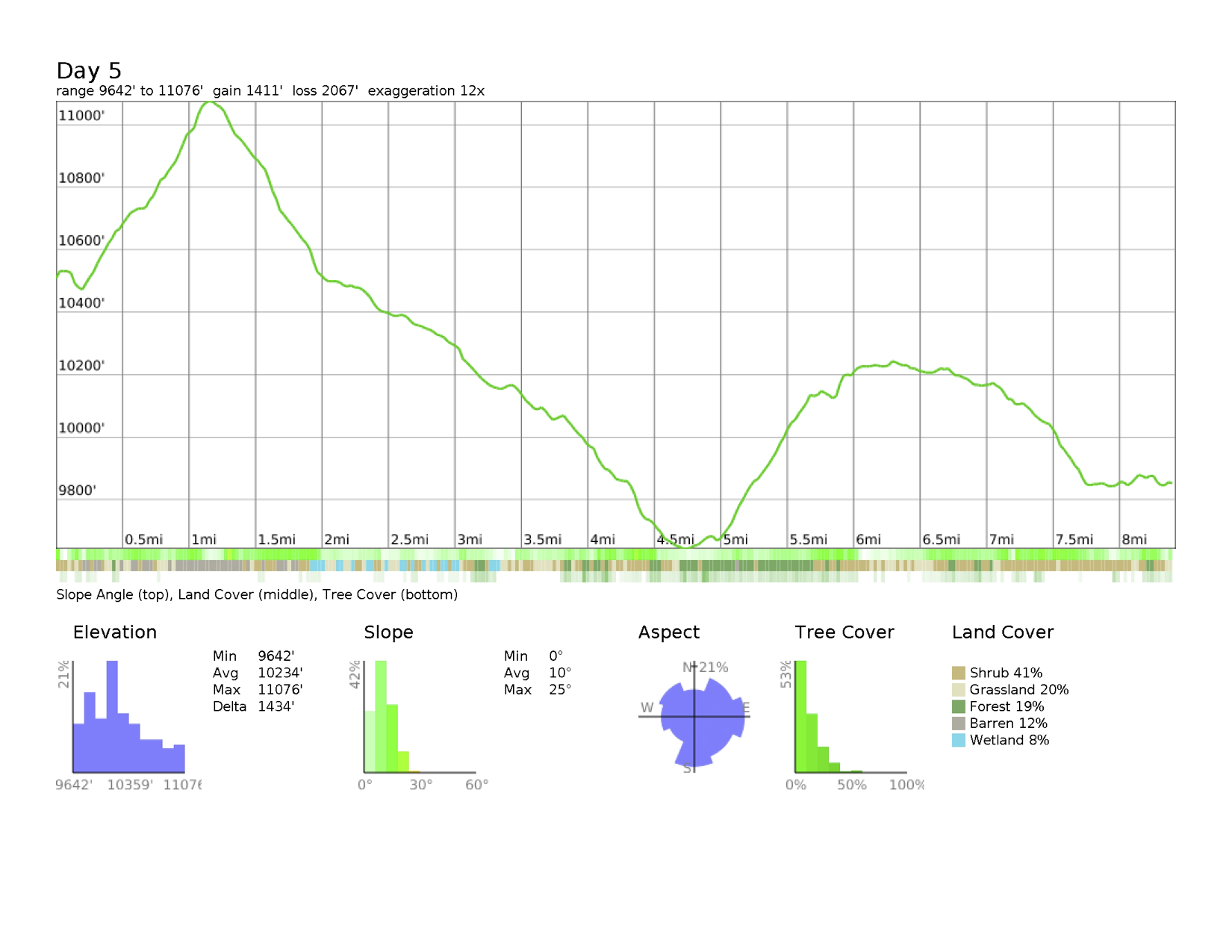
 Day 5: Lyell Forks to Thousand Island Lake
Camping at 1000 Island Lake in the shadow of mighty Mt. Banner. All of the Ritter Range look as though they were born in violence, a cataclysmic rock fountain that shoved these massifs vertical into the sky. They are truly awesome in their engineering from the earth. Today was Donahue Pass followed by Island Pass. The first was very exciting as Mike and I summited basically together. The second was a slog even though it is lower. The weather has turned windy and clouds are interrupting the sun’s communication to us. Some rain and hail at lunchtime. On Donahue, I recognized Mammoth, June, and the Minarets – it felt like home! Also, met a 60-yr-old man (Kip?) who was climbing the pass 51 years after his dad took him there. We talked for a second about our lost dads. Met more JMTers and Pebbles, who said she was the last PCTer I’ll see. Once I got to the lake, I was drained. My knee and body are doing ok but just wiped out. I took my time and did a first – a bath with soap! I feel much better. Still slow but human again. There’s lots of camps around my little rock valley heading down toward the water. There’s a guy above me and two women in the next rock crevasse over. Maybe I’ll be social, maybe not. My guess is that Mike went on to Garnet Lake, which he needed to. I honestly can’t imagine doing more than 10 mi/day. Well maybe with a lighter pack.
Day 5 Map
 Day 5 Profile
 Day 6: Thousand Island Lake to Rosalie Lake
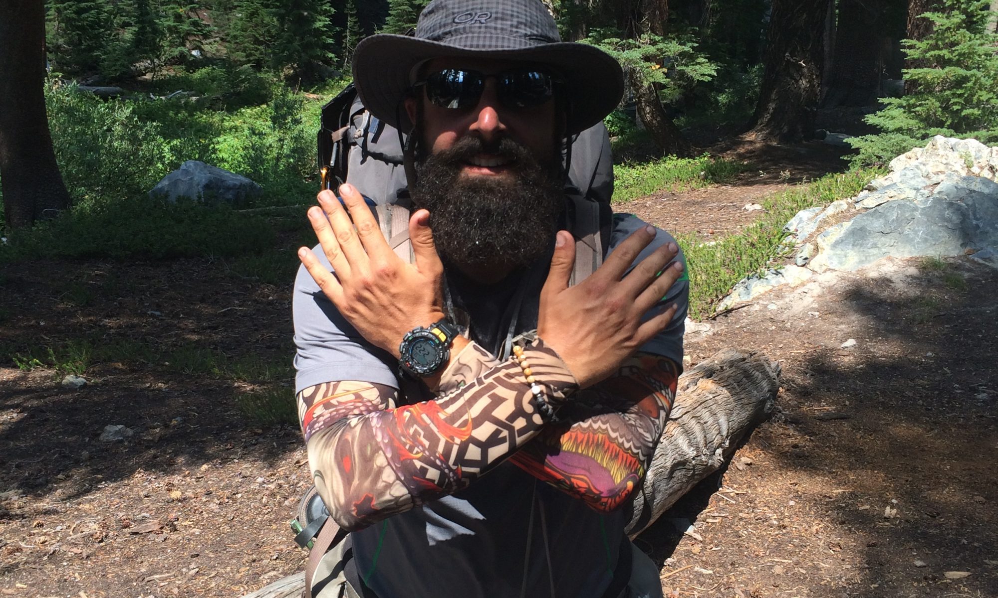
What a great day! I started slowly (9:05) and worked my butt up and out of 1000 Island Lake basin. I bumped into Jon from Lyell Forks and we started hiking together to Garnet Lake. He’s a fun free spirit with intelligence. We soaked our feet at the lake and started climbing out where we ran into Chris and Nat. The four of us made a small pack and hiked the rest of the day to Rosalie Lake. There was an intense climb from Shadow Lake and they let me take the lead until I gassed out. Chris gave me tattoos. I look like a badass now with the beard and sleeves. Chris is a real estate investor, Nat a math teacher. Chris and I connected easily and we had a great time chatting. Nat is a super cool guy who is down to earth. We arrived at the lake and took a swim, which was glorious. After chores, Chris and I talked more about the past and future. I had told them about my trail project and they were all excited for me. It was fun to use some of these words today: marry, engagement, fiancé, ring. Am I really doing this?! Yup! We had dinner and a campfire, drank whiskey bourbon (less weight!) and called it a night. I’m super happy – this is what I was open to happening. Tomorrow though they will move on and I’ll be the ghost they passed through. Hopefully I can stay in touch with these guys – I like them. It was so much fun to be talking and telling stories, trading ideas for weight reduction and just being out.
Day 6 Map
 Day 6 Profile
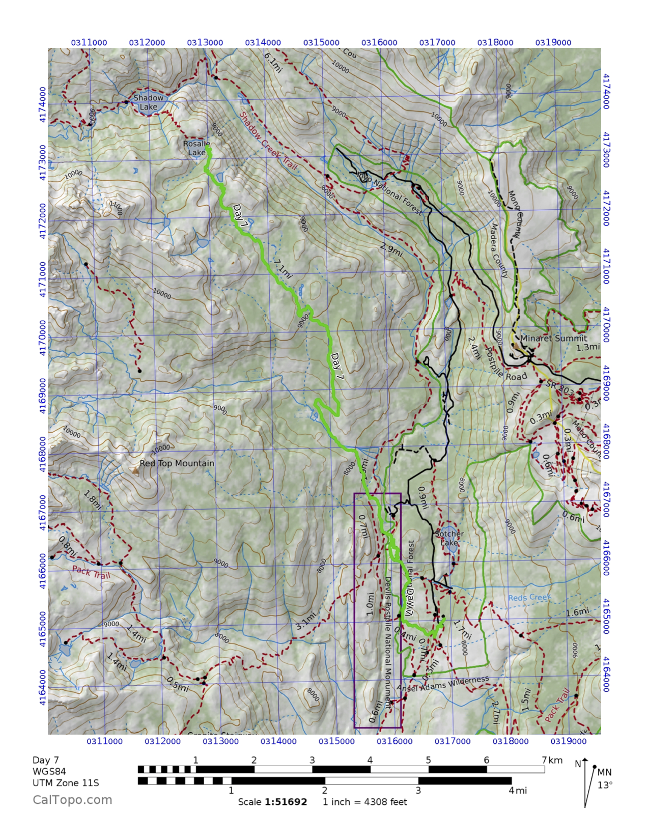
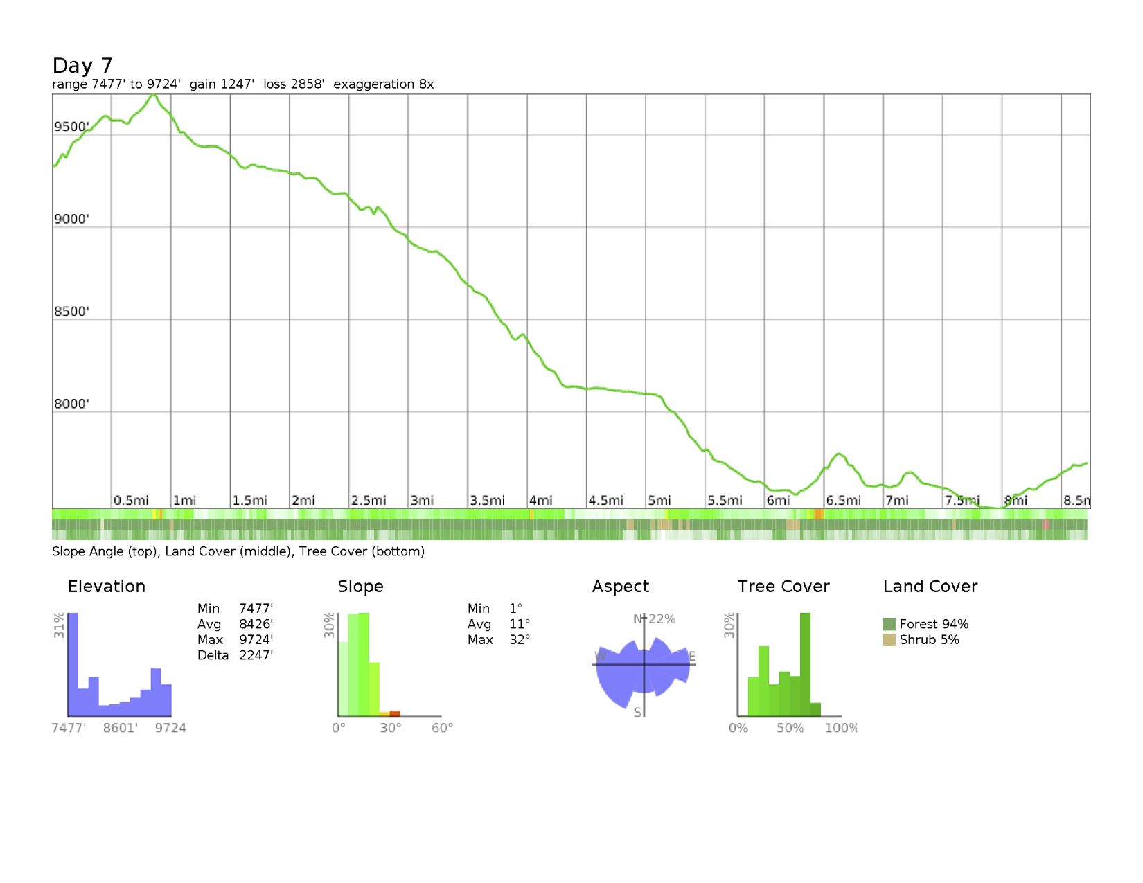
 Day 7: Rosalie Lake to Mammoth Lakes
Another enjoyable day coming down through parts I know – Devil’s Postpile and Mammoth. I was a tour guide for our little pack of Chris, Nat, and Jon. We slogged up to Red’s Meadow because Nat was leaving and while I soaked my feet in Minaret Creek, Chris reserved a room at the resort. After a hearty lunch, Nat left and we killed time until the room cabin was open. It slept 5 people and we absorbed Jon, Liza, and David. Super fun! Showers were had, cleanliness all around. Then the redirection of my trip began. I was sharply torn between sticking to the complicated program I set up with people coming and going or ripping that up and embracing my new trail family. Chris and I particularly bonded. Jon and I also have great chemistry. And Liza and Dave are just very kind, fun people. I didn’t want to lose the community that I’m part of. I talked with Peter and his advice was to do what I wanted with the trail – it’s my hike and if I want to change it, change it. Such good advice. I decided to take the temperature of all my hiking peeps and eventually went with a total overhaul. I took the last bus out of the resort, Uncle Joe picked me up and I spent the night at the condo redoing and resupplying. Some extra items Liz was bringing on Wednesday (tomorrow) were foregone. It was nerve wracking and I felt bad about the huge disruption I was causing. I went to bed at midnight after laundry was over and was out from the hiking, the pizza dinner, and the emotional rollercoaster of what to do.
Day 7 Map
 Day 7 Profile
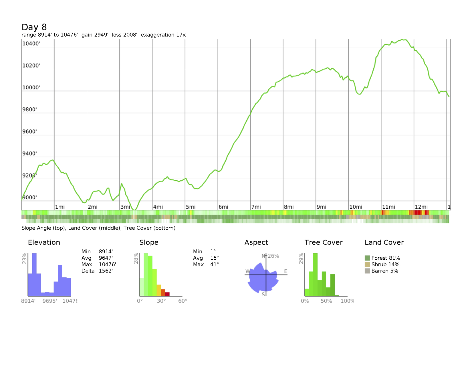
 Day 8: Mammoth Lakes to Purple Lake
I’m so happy I surrendered to the JMT. The trail told me to continue, to stay with my trail family and trust that the right things will happen. I had a huge breakfast at the condo and then a marvelous goodbye from the Unises and vonMayrhausers at Horseshoe and McCleod lakes. I chatted with Kathi for 15 min during a break on the trail over Mammoth Pass Cutoff, which was great. After a long dry march toward Duck Lake Pass, I found Jon, Liza, and Dave at the creek! Jon and I went on together after the others left and we arrived at Purple Lake after a fun chat about the Middle-East scene and random things. My beard and tattoos remain quite distinctive on the trail and Chris had used them as descriptors to pass messages down on where to find him. It was entertaining to be known on the trail. Finally arrived at the lake and the warmth of welcome made every decision I made correct. I was home. We had a nearly communal dinner with sharing of food, drink, and dessert. This is where I’m meant to be right now. I love it. I have not been this happy in years. It’s a place of transient people experiencing something together and that is truly amazing. Rok on!
Day 8 Map
 Day 8 Profile
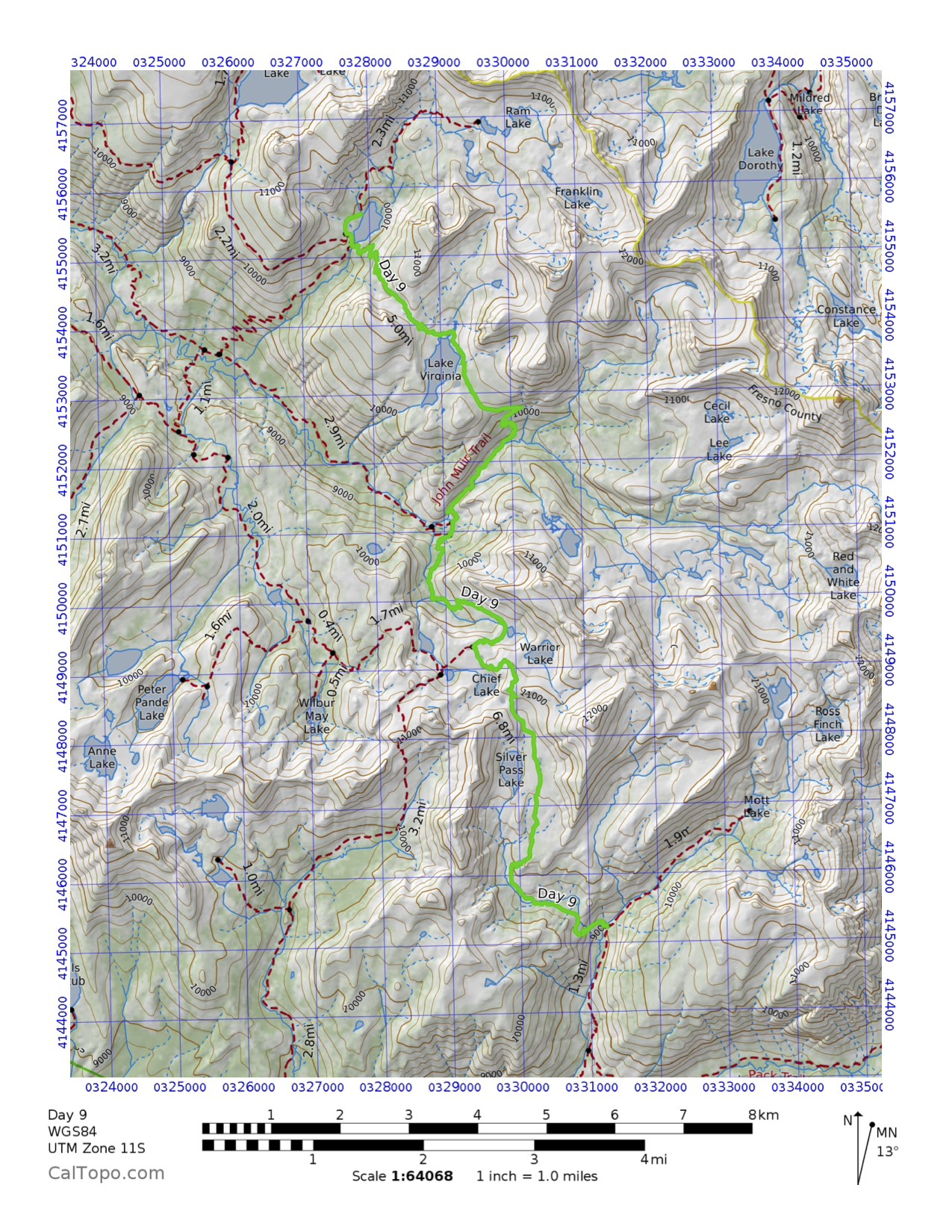
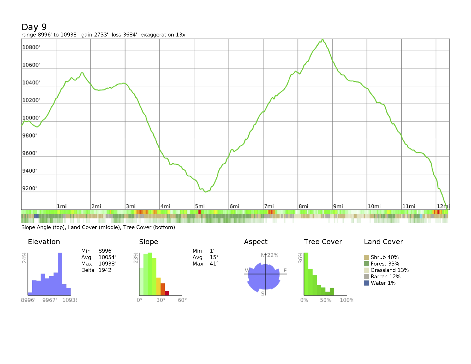
 Day 9: Purple Lake to Mott Creek
I’m exhausted. Again. And a bit pissed at myself. I don’t need to be hauling along at 12+ mi/day paces. This is not the hike I want to do. Did I fuck up by leaving my plan? I like Chris’ company a lot but this isn’t what I need to do. I am missing scenery and lakes and downtime that I so desperately want. I need the return to my freedom but I like being with another person. This is hard. We went over Silver Pass today which was a slog but beautiful. I had wanted to stay at Silver Pass Lake but we decided to push on an extra 3 mi. Well those last 1.5 mi were horrible down switchbacks and I just hit the limit. I’m not happy because we hiked so much today and there were not any rests to just relax. Then we got into camp at 5:30 without any time to do chores, like laundry. I’m not ok with this because I do not have to be moving at this pace! I want to see the stars at night and sleep until I want and yet company makes me safer – a trade-off I need to figure out how to balance.
Day 9 Map
 Day 9 Profile
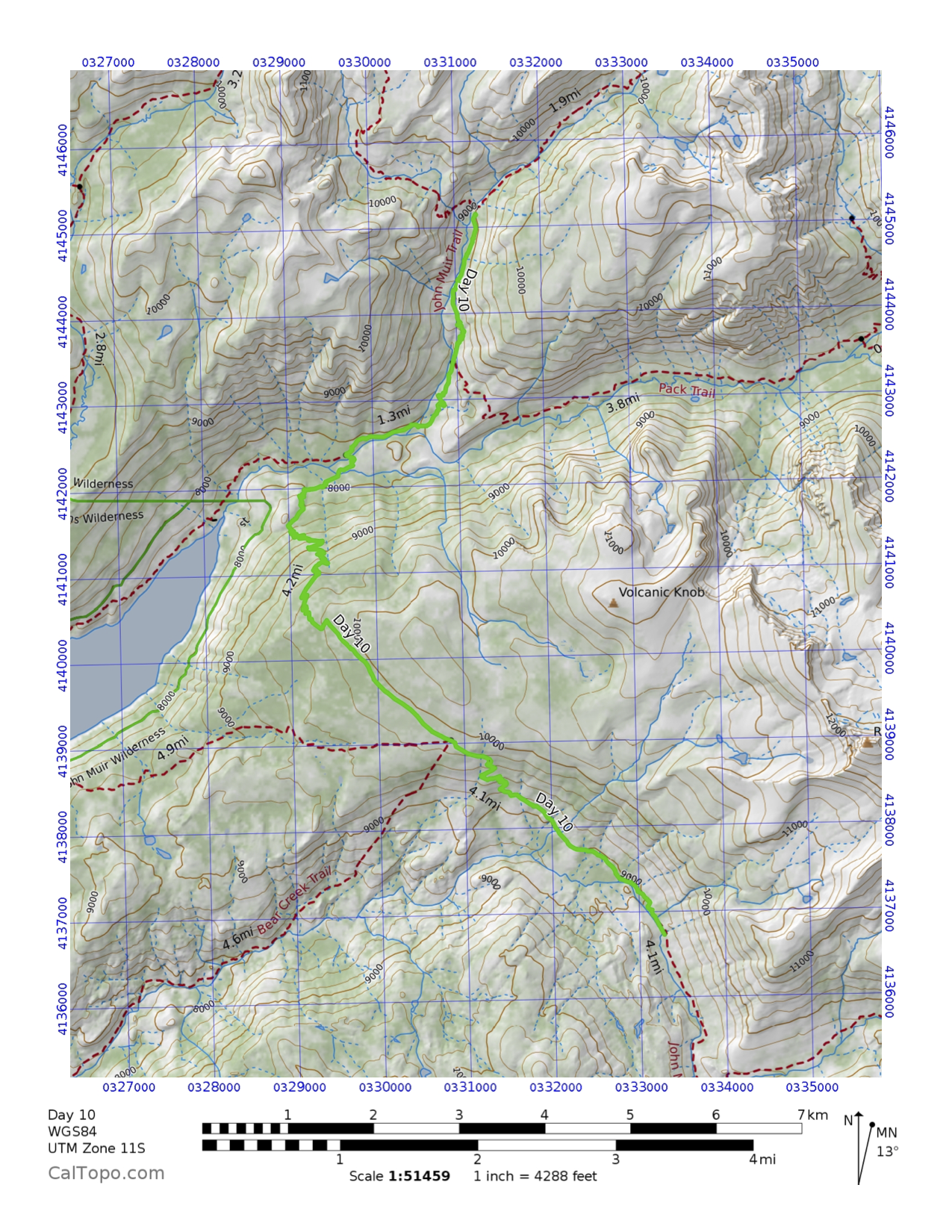
 Day 10: Mott Creek to Bear Creek
So much happened today. Let’s go backwards. Stargazing chat with Jon. A 5-guy dinner with Chris, Jon, Ralph, and Richard. Full laundry and near full bath in Bear Creek. Long down trek from Bear Ridge in the rain and hail. Talking to Mom and Peter at the ridge in the rain and thunder. A happy solo hike through lodge pole pine forest on the ridge. A recharging fun lunch with Chris on the way up the ridge. A slog up the ridge in humid, Jurassic Park-like meadows. A goodbye to Liza and Dave at the footbridge over amazing waterslides. A long down from Mott Creek or Grand Central Station in humid cloudy conditions with glimpses of huge mountains of granite. A wake-up slowly morning in the rain. Chris said there is nothing small about me – my stature, my personality, or my calves (!). Jon asks very deep philosophical questions such as “Why am I on the JMT?” And during our chats, he says he learns a lot from me. They are both so different and I enjoy them so much. I enjoy talking nature with them, especially Chris because he would just plow through but once I stop to talk about something, he’s totally excited. Today we saw cedars and stopped to smell their bark. As you do.
Day 10 Map
 Day 10 Profile
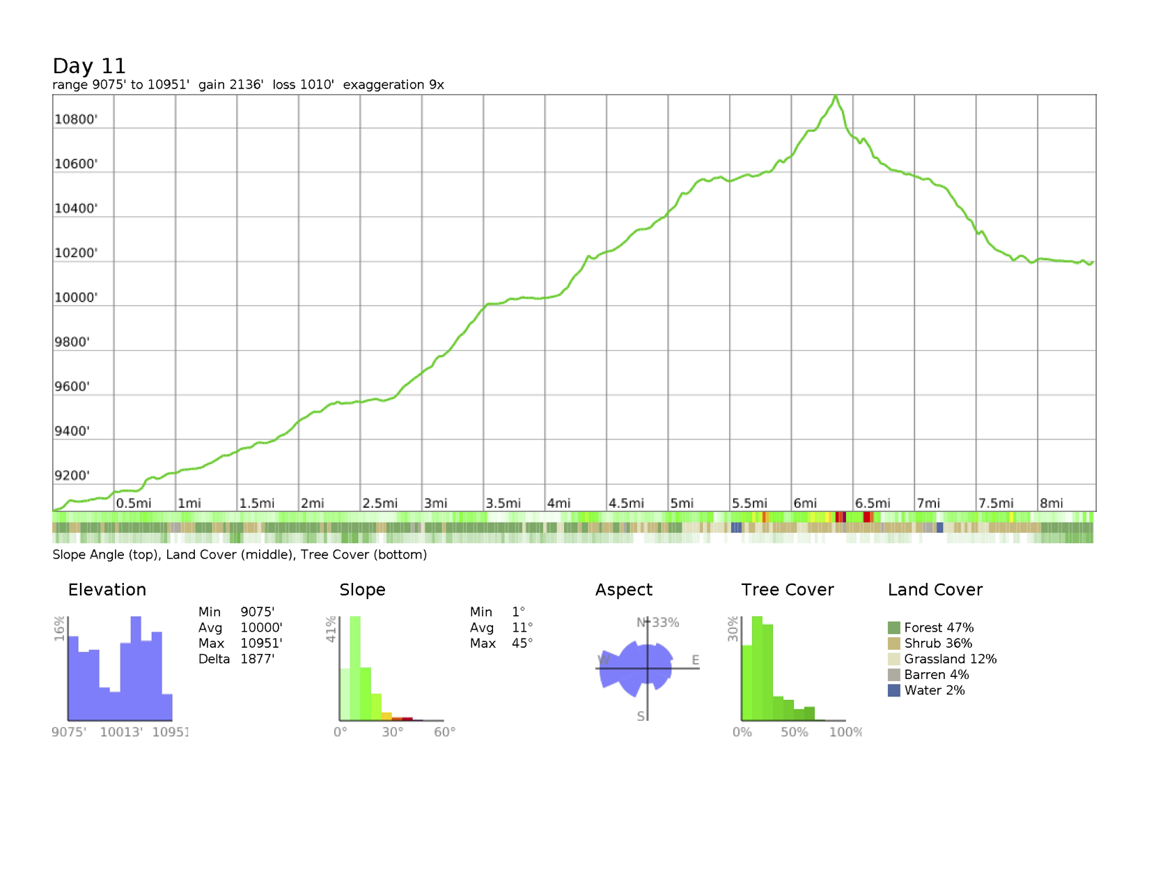
 Day 11: Bear Creek to Sallie Keyes Lake
Today Chris and I parted ways at Marie Lake at lunch. He wants to go faster than I do and I am realizing that I am not into pressure from others (not that he was, just in general). I am bummed and he was too but we both knew it. Now I’m back to planning anxiety because I messed up my schedule. This is not good. Maybe this overnight high up at 10000’ at Sallie Keyes Lakes will help out! It’s amazingly beautiful but especially cold. And this isn’t even my highest campsite?? Hmm. Tomorrow at Muir Trail Ranch (MTR) I’ll work to reset things. Lowlight – I broke my poop shovel. Highlight – Marie Lake and then an osprey over Sallie Keyes Lake.
Day 11 Map
 Day 11 Profile
 Day 12: Sallie Keyes Lake to Piute Creek
Many things happened today – a stop at MTR, entering Kings Canyon National Park, communicating with the outside world, very clear change in climate from moist alpine to desert-like canyon country. Jon and I picked up our resupply buckets and now I am carrying a 54 lb pack with food for 11 more days. This is crazy! We had to hang 3 bags of food tonight even! I’m having a very nice time with company and routines that vibe well together. Steve, the Trout Whisperer, is a hoot – a 48-yr old busy body full of great energy and humor. He’s camping with us tonight and after dinner we drank in the night sky for a bit. Piute Creek is roaring nearby and I took a good soapy bath before dinner in it – wonderful! I will be honest and say at one point on the long downhill today to MTR, I thought I could just keep walking off the trail. I’m done, but I knew that was because the trail was so miserable and hot. What I’m loving most is the lack of pressure from the world. It’s just me and the JMT and we are having a conversation every day. I hope I’m listening to it as much as I’d like to believe I am. Lowlight – the anxiety of food resupply and communications with the outside world. Highlight – seeing Liza and David walk into MTR and catching up with them. And the night sky with the Milky Way.
Day 12 Map
 Day 12 Profile
 Day 13: Piute Creek to McClure Meadows
I got beaten up today even though it was a short day. The 54 lb pack, now lighter, is crushing. We went up the San Joaquin River to Evolution Creek to McClure Meadow today and while the elevation change and elevation itself weren’t particularly large, it exhausted me. Plus I don’t know if I’m managing my food right. I think I can eat more than I am because in 10 days I will be at Whitney Portal. The beauty of this meadow is amazing with sunlight streaming over a broad green plain and the creek meandering happily. Some very large deer or some mountain herbivores are grazing in the meadow while massive granite polygons watch from above. Every shape is represented from flat top to sharp peak. Jon and I have a shady camp that the afternoon is filtering through trees that sigh with the wind. I hope it won’t be as cold as this morning when it was below 40F. I slept on a rock for a good hour after we arrived then deleted tons of texts to save space for photos and video. I’m starting to get worn a bit from the constant action and chores and setting up and taking down. Somehow the second half of the trip will spark anew I know but right now, I’m hungry, tired and looking forward to getting past some of the big passes just around the corner. The best thing I can ponder is that my pack will only get lighter from here to the end!
Day 13 Map
 Day 13 Profile
 Day 14: McClure Meadow to Unnamed Lake
This was a mixed day of slog and beauty. Up from a frost-covered McClure Meadow to Evolution Lake where the mountains were blocks of fierce granite. Up to Wanda Lake above the treeline where grasses and unfiltered sunlight drenched the lake basin. Up to Muir Pass above the green line where rock and rock and rock dominated to Muir Hut where we met a ranger full of bounce. Then down to Helen Lake and a barren landscape of ice, snow, water, and rock. For miles in all directions, there were brown and black rocks. The trail was snow-blocked at one point – the first that has happened. Down to a canyon as the sun faded behind a mountain into a verdant valley finally with water tumbling from hillsides and walls of granite (green, black, and gray). Eventually as my body said enough we found a campsite on a peninsula between a lake (unnamed) and its outlet creek occupied by a couple and a solo hiker. We squeezed in, ate dinner, setup camp, and surprisingly, stayed up with the solo watching the stars. I was so cold, though, that my tent called me in and I brought everything inside – gas, water, water filter, charger. Good thing too because overnight, the temperature hit freezing. That’s what camping at 10,000+’ will do – freeze it all! We added about 4.5 mi today so tomorrow will be thankfully shorter and that means a partial rest day. I’m good with that because all the up and down took a toll on my legs and they are sore for the first time. Jon and I are sticking together and it’s working well. We don’t necessarily hike all day together but we stop and lunch or break and check-in. It’s great. He’s a fun guy full of good energy and wonder of the world. Tonight he and the solo hiker are singing together while I snuggle in my tent thinking of warmth with Kathi.
Day 14 Map
 Day 14 Profile
 Day 15: Unnamed Lake to Middle Fork King’s River
The Middle Fork of the King’s River is roaring by while a ¼ moon paints the sky and the inside of my tent pale white. This was supposed to be a mellow part-day with some downtime but we ended up pushing a good 8.3 mi, mostly to find a better campsite (~3 miles of that at the end). I got stung by a wasp at one of the potential sites and grabbed my stuff and left. The glacially carved valleys above the main flow are amazing – hanging valleys with sheets of water cascading down. That has made for a huge flow near our site, which meant laundry and a bath while the sun was still up. We worked on our food and calendar – it’s a bit nerve-wracking to think I have no emergency food really. But 8 days left and only 7 dinners! 🙂 I’m both ready to finish and used to this life. The wildness and novelty have merged to just be existence. And I enjoy the company. But Jon may have to go a day faster because of food and I have a sad feeling that I’ll end up on Whitney alone – none of my trail buddies and none of my real life buddies. I am counting on the trail to reveal what will happen. I must trust the JMT.
Day 15 Map
 Day 15 Profile
 Day 16: Middle Fork King’s River to Upper Palisade Lake
The day of the Golden Staircase. We went up from Palisade Creek through a beautiful valley with sequoia and wildflowers aplenty. Second John joined us and we had a fun triple all the way to Upper Palisade Lake. The mileage was short but the climb intense. We actually took a very slow enjoyable pace so at no point was I burned out. However, my food just isn’t cutting it for lunch. I know I need more but I can’t carry more. This challenge is stupidly my fault to forego a 4th resupply. My one hope is that Justin and Matt are indeed coming on Saturday and bring some food unrequested. Jon got some trail love today from the kitchen of the trail workers who gave him an apple, an orange, and a tray of brownies. He shared the fruit and gave me the brownies as a birthday present. During our post-dinner card game invented by John, we ate half the tray. Yum! The scenery here at the lake is gorgeous with the Palisades jutting aggressively vertical into a crystal sky. Tonight is the beginning of the peak of the Perseids but it is so cold already (and I’m not using my headlamp) that I doubt I’ll see much of them! In two more nights, I’ll be lower again to 8500’ so perhaps I can stay up! Tomorrow is Mather Pass and it looks daunting right now looming from above us. It will be a tough long morning but we can do it! I know I can. My pack is getting lighter, even with half a tray of brownies to heft until tomorrow night. 🙂 And in 7 days, I will be sitting in Mammoth, showered, well-fed, and ready to sleep in a bed. Can’t wait! But this adventure is truly a singular experience as a first time. Why rush that?
Day 16 Map
 Day 16 Profile
 Day 17: Upper Palisade Lake to Marjorie Lake
The End of My 30s. Went over Mather Pass this morning – which was hard – and ended at Marjorie Lake at 11,070’. Another cold night is setting in. I feel ok though but look forward to a good eating day tomorrow. Nothing particularly notable happened today. The scenery changed to a drier eastern Sierra climate with short lodgepole pines. We had a long uphill after bottoming out and John took off on his own. There was much time spent solo hiking today and my mind did wander. Seems strange to be hitting this milestone alone out here but this is where I am so embracing it and moving on. I suppose.
Day 17 Map
 Day 17 Profile
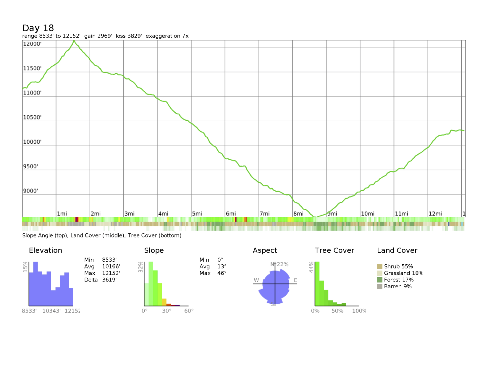
 Day 18: Marjorie Lake to Arrowhead Lake
The Beginning of My 40s. It was a long hiking day – 13+ miles and that included Pinchot Pass and 7 miles of downhill through dusty dry country reminiscent of northern Arizona. The terrain changed from high alpine to high pine forest to lower riverland back up to mid-level lakes. At the suspension bridge, where Jon was waiting for me (I hiked solo for many hours today), we met Coleman. He’s been THE trail angel I have only hoped for – he gave us food, then offered to fish for dinner, and now just offered to carry out our trash. He caught 3 trout and those went down so well with my lasagna and the others’ dinners. We had a mini-birthday party with ice cream (astronaut of course!) and the trail brownies and a beer from Coleman. So much fun. I trust the trail. I was feeling strange being out of touch from family and friends. I still do a bit. But I did talk to Dad today for a brief moment and hope that when I re-emerge in a few days, the love will be there waiting. Tomorrow is Glen Pass and then hopefully Matt and Justin to disrupt the monotony of things. It will be hard to say bye to Jon I think because the last 2 days I will be solo again.
Day 18 Map
 Day 18 Profile
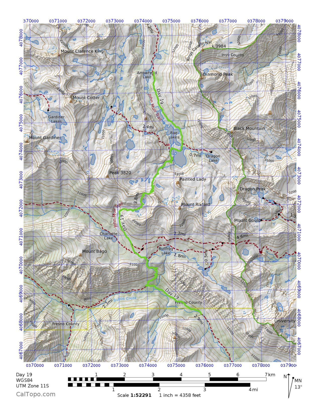
 Day 19: Arrowhead Lake to Vidette Meadow
Short entry – Glen Pass brutal. Lots of rock, very steep downhill. Very dry on opposite side compared to Rae and Arrowhead Lakes side. Met up with Matt and Justin at Bullfrog Trail Junction. I was so excited I ran to them. We all hiked to Vidette Meadow and found a large site along the creek. Laundry, dinner, bath(ish). They brought a small cake for me with electric candles. Made plans for Forester Pass tomorrow. A bit nervous because my hip was sore a little today. I may end up coming out on 8/16 anyway just to be done! I’m ready. Seeing friends makes me want to both do more and leave at the same time. Huh?
Day 19 Map
 Day 19 Profile
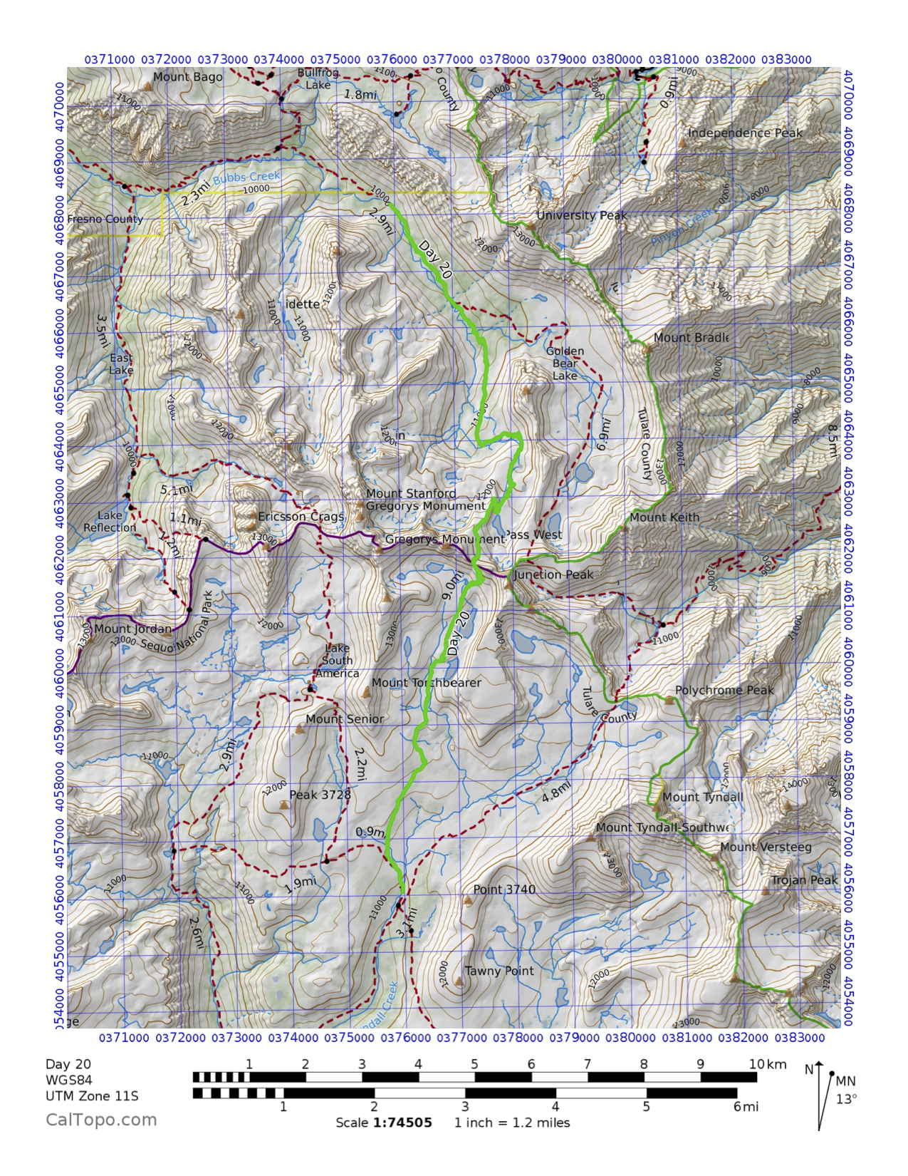
 Day 20: Vidette Meadow to Tyndall Creek
Forester Pass. We (Justin, Matt, and I) climbed up through the valley through the trees into the scrub and finally rockscape en route to Forester Pass. The scale of the rock walls was magnificent. Arriving on the pass was the slowest slogfest yet, which makes sense – it’s 13,100’. We had lunch up there and spent some time taking photos. So much fun with those guys. On the way down, which was terrifying in its vertical descent, we noticed a lake shimmering at the base of the switchbacks. We stopped for foot soaking and water filtering. It was a great break because soon after, we began the driest 5 mi I’ve done on the entire trip through a valley that was broad and sun-baked. There were some small white clouds that cooled the air a bit but otherwise, it was dusty and stark. This seemed to fit the Eastern Sierra I imagined. Eventually we made it to Tyndall Creek area where Jon had found a site 2 hours prior. I did chores and tried to deal with my food but failed. I’ve decided that I’m coming out at the Portal on Tuesday, 8/16 on D22. I’m done. I want to go to places with food and water and beds and end this amazing journey. The trail has told me to go home. I’ll listen.
Day 20 Map
Day 20 Profile
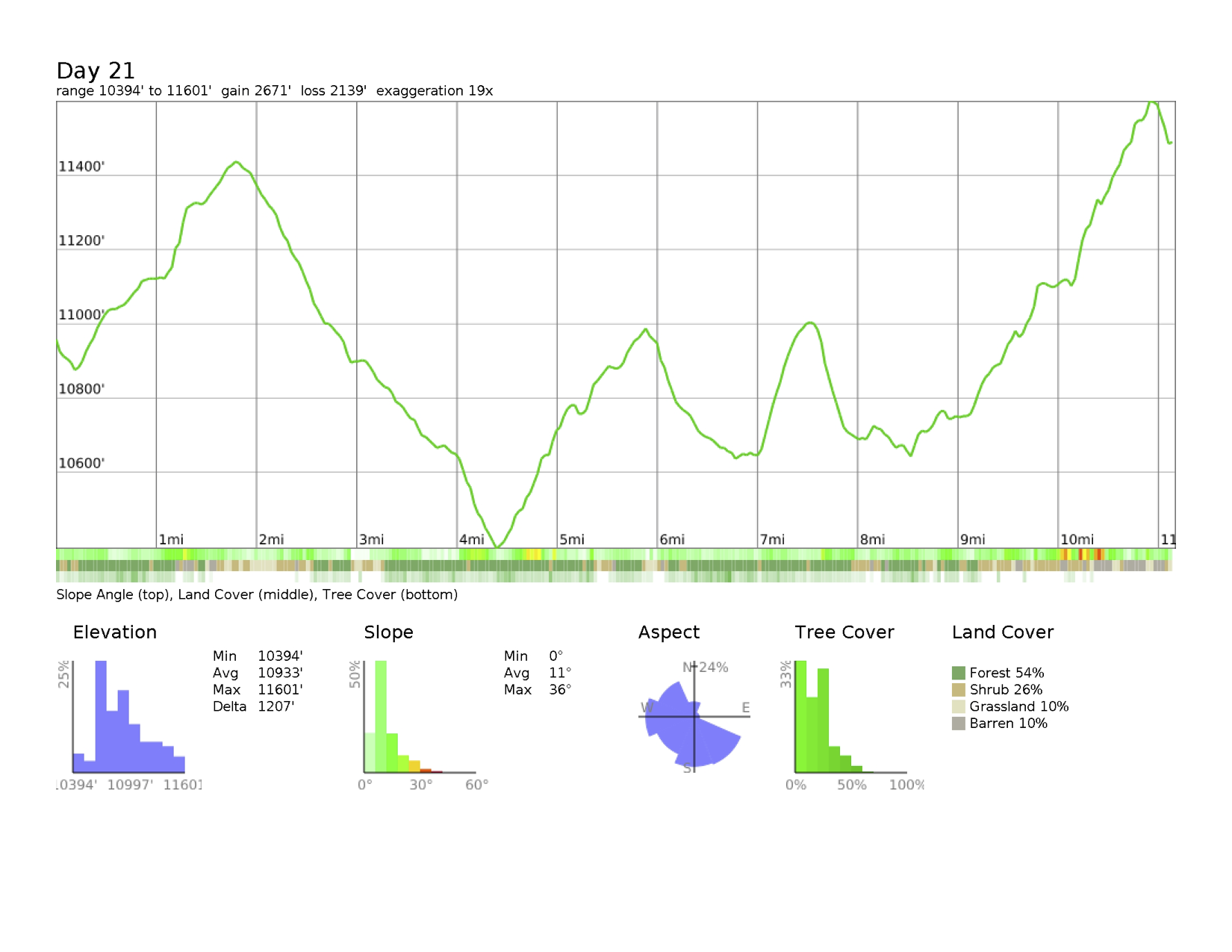
 Day 21: Tyndall Creek to Guitar Lake
The End of the Line. Mt. Whitney summit is 4.6 mi away as the moon shimmers over Guitar Lake and the wind fluffs my rainfly. Today’s journey was mostly solo as Justin and Matt left and Jon went earlier than I did. The landscape was big – wide open broad valleys, rounded hilltops with glacial deposits, forests of huge lodgepole and Jeffrey pine with multi-hued skeletons of dead trees interspersed among vibrant green ones. It was dusty and warm so a foot soak after a drive by at the Crabtree Meadow Ranger Station for the wag bag was wonderful. Eventually arriving at Guitar Lake in mid-afternoon allowed a refreshing dip and hours of hot sunshine to warm up. I had lost myself in imagination for the first part of the day and so meeting new people at the lake (or at least from yesterday) was nice. They are in their 20s and 30s but I fit in fine, especially because one of them (Click) is in her late 30s. We had dinner together on the rocky outcrop they are camped upon and played a version of 2 Truths and a Lie before just chatting. Then I asked everyone to say what they had learned on the trail. Some of the answers were quite practical while others were more what makes a person like or dislike backpacking. I said my piece about surrendering to the trail and going with it and ended by saying that would be my theme for my 40s. Lots of nodding heads. And then a fun discussion about all the different trail magic we experienced – lost shoes, found jelly beans, food, replaced shoes, the general vibe of bonhomie. We took some fun photos and Jon and I departed for our tents as they all are sunrise-on-the-summit bound. Good luck to that! We have our own 6:00 departure planned. Earliest one yet. But I am really humbled by this whole journey.
The hardships, the pain, the scenery, the people, the introspection, the peacefulness of continual absenteeism, the loneliness, the animals, the fear of camping alone, the food desires, the hunger, the hard slogs, the constant chores, the sky at sunset, the twinkle of stars, the powerful glow of the moon, the rush of water, the sigh of wind, the harshness of water or wind or sun or cold, the shock of ice water against a hot body, the smell of pine forest, my own smell, the need for personal care, the sleeping on the ground, the schlepping of my worldly possessions on my back, the menus, the breakdown of my tent everyday differently, the tending to a million little things while still finding peace and calm inside. This was hard – very hard – and I am so happy I’ve done it. Who knew I could carry 12 days of food 110 mi in a pack that started at 54 lbs? This has probably changed me less than I expected but more than I know. It’s been beautiful and hard and calming and nervewracking all at the same time. And there are 5 mi to go. And a summit to climb. And a life to live. Thank you JMT.
Day 21 Map
 Day 21 Profile
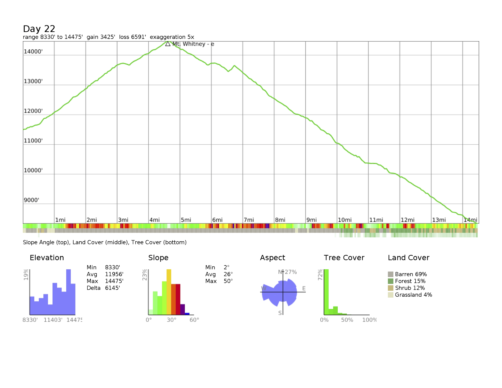
 Day 22: Guitar Lake to Mt. Whitney Summit to Mt. Whitney Portal
So much for that 6:00 departure. “Doug, good morning. Doug, good morning” came through my tent at 2:30 am from Jon. He wanted to head up to the summit for sunrise. I rallied and we did get moving before 4. The moon was tickling the sky for a few minutes before disappearing behind a ridge, leaving us with just the stars and our headlamps. Some lights were dancing above us at the top of the trail near the trail junction. We puffed our way in the dark and hardly stopped. The air was cold but I was sweaty. My pack wasn’t as light as I hoped it would be by now. The sky changed from black to tones of gray and then pink painted the cliffs and granite towers below us. We arrived at the trail junction at 6:15 just as the sun rose in full. Jon went on faster to try to catch our summiting friends but I knew that I wouldn’t make that so I watched the sunrise from between the first needles. It was a silent moment with the rays exploding at once across the eastern sky and a vibrant yellow orb rose unimpeded by clouds or haze. I realized I didn’t have sunglasses with me. I began the final 1.9 mi of the JMT that picked its way along the rocky trail I did with Peter and Liz in 2009. I hardly remembered it and for good reason – it sucked. I crossed paths with the Canadian father-son pair as I came up the final curves and said our goodbyes as they were heading down. It was a heartening moment at 7:30 as I neared the hut on the summit and the sun was so intense that it seemed to be echoing off the rocks around. I signed the book for the people who should have been part of the JMT and Dad and then found the crew of 5 plus Jon already there, 15 min before me. I was done!! The JMT and I were at the end of our time together and here, on top of the 48 states, we parted ways. I jumped for joy with my shirt off and yelled “this is 40!” while the rest of the crew laughed and wondered why I was half naked in the frigid sunlight. After sending text messages, posting on Facebook, and calling Peter, and making my final video log, the descent began. Click and I did most of the first half down to Trail Camp together along with Cracken, talking about life after a big through-hike. Some young guys planning to do the JMT next gave us two fruit cups and jerky. The trail was much more crowded with day-hikers and overnighters and I could actually smell a difference with perfume, cologne, after shave, fabric softener, deodorant and just cleanliness. It was wild to perceive all these smells and think of them as almost foreign to the JMT. The knee busting downhill of the 99 switchbacks was a memory from the first time that I didn’t need. We all eventually stumbled into Trail Camp where Click and Sprout were going to stay. The rest of us were moving on and they joined us. Jon and I traveled together for awhile under a blazing hot noonday sun. The last mile was endless and I stopped many times to check how much farther I had to go. I didn’t want to end but I was done with the trail and actually annoyed with this part. But several people heading up were so congratulatory and encouraging that the end was in sight. I remembered the last time I came down was in the dark and under a cloud of frustration. This time was under a cloud of exhaustion blended with calm excitement. Finally the last turns brought me stumbling out through the wooden frame that I remembered and I weighed my pack – 42 lbs. So there it is – I just can’t get below 40 lbs. I found Potter, Jon and Sprout already down at the store where a grill and ice cream awaited. Soon Matt showed up from his adventure with Justin as the rest of the crew rolled in. We had beers, food, more food, and tried to figure out what’s next. I couldn’t convince Matt to go to Mammoth, which was going to add 200 mi to his drive that would have really made his trip rough. The trail crew decided to stay in Lone Pine and we all crammed into Matt’s truck for a lift to town. Many beers later and half of an 18-lb watermelon, we found ourselves showered and eating at the Pizza Factory – exactly the same place as last time I did Whitney. What? The trip was really over and there was a buzz of strangeness all around for me that I have a hard time capturing in words. Familiar yet unnecessary comforts maybe? I’ll come up with it someday. We split 2 rooms at the hotel and watched the Olympics. The crew surprised me and Jamie with a birthday key lime pie with enough candles to burn down the seedy hotel. Finally, around 11, the goodnights and goodbyes were said as I will be on a 6:15 bus to Mammoth. I’m not ready to re-enter the world of wheels and computers but I can’t wait for my new life to start. Does that even make sense? I think to a through-hiker it does. And I guess that’s what I am now. Thank you again JMT!!
Day 22 Map
 Day 22 Profile
 Day 333: Red’s Meadow to Mammoth Pass Cutoff Trail
The Final Steps. Nagging in the back of my mind were the 3.7 miles that I skipped when I left Reds Meadow near Mammoth and rejoined the trail out of Horseshoe Lake. Life is radically different now. I proposed to Kathi in September and we got married in April! I had a special quartz piece I found on Day 20 turned into her birthday necklace for her to always feel a closeness to the JMT – the trail that closed one part of my life and prepared me for the rest of it as her husband. I made a film about my trip and screened it in November. Yet there was a gap between Reds Meadow and Mammoth Pass and between Kathi’s and my experiences. So today we closed it. It turned out that doing the 3.7 miles meant a total of 11.7 miles to access the trail, wrap our way up by Red Cones, and then separate from the trail in triumph (and a meander in reverse of what I did on Day 8). She got to see the Sierra blue sky, taste the dusty air, feel the sun and clouds dance with the warmth, and scamper over swiftly flowing creeks. We went deeper than just the physical experience and explored where we were in July and August 2016. The crunch of the dirt and pine needles and sometimes snow underfoot formed a soundtrack to our emotional ride. And then when we arrived at the exact point where I had stepped back on the trail almost one year ago, I stopped. Truly completing it took me to a euphoric and pensive place, not dissimilar from the summiting of Mt. Kilimanjaro ten years ago with Peter. Kathi filmed the moment and overcome with the magnitude of my feelings, I fumbled through a stream of consciousness. I’m done! I finished with my new wife! I can’t replicate the moment on top of Mt. Whitney but there is a true end to this story now – and I am so happy I was able to share that with Kathi.
Day 333 Map
 Day 333 Profile
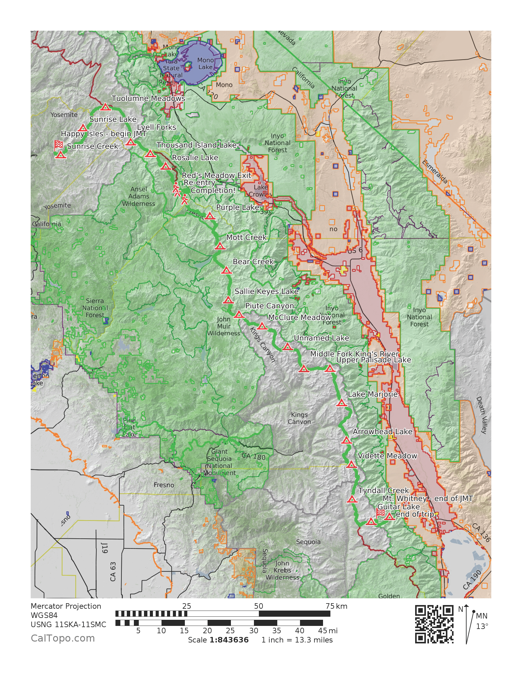
 John Muir Trail Map
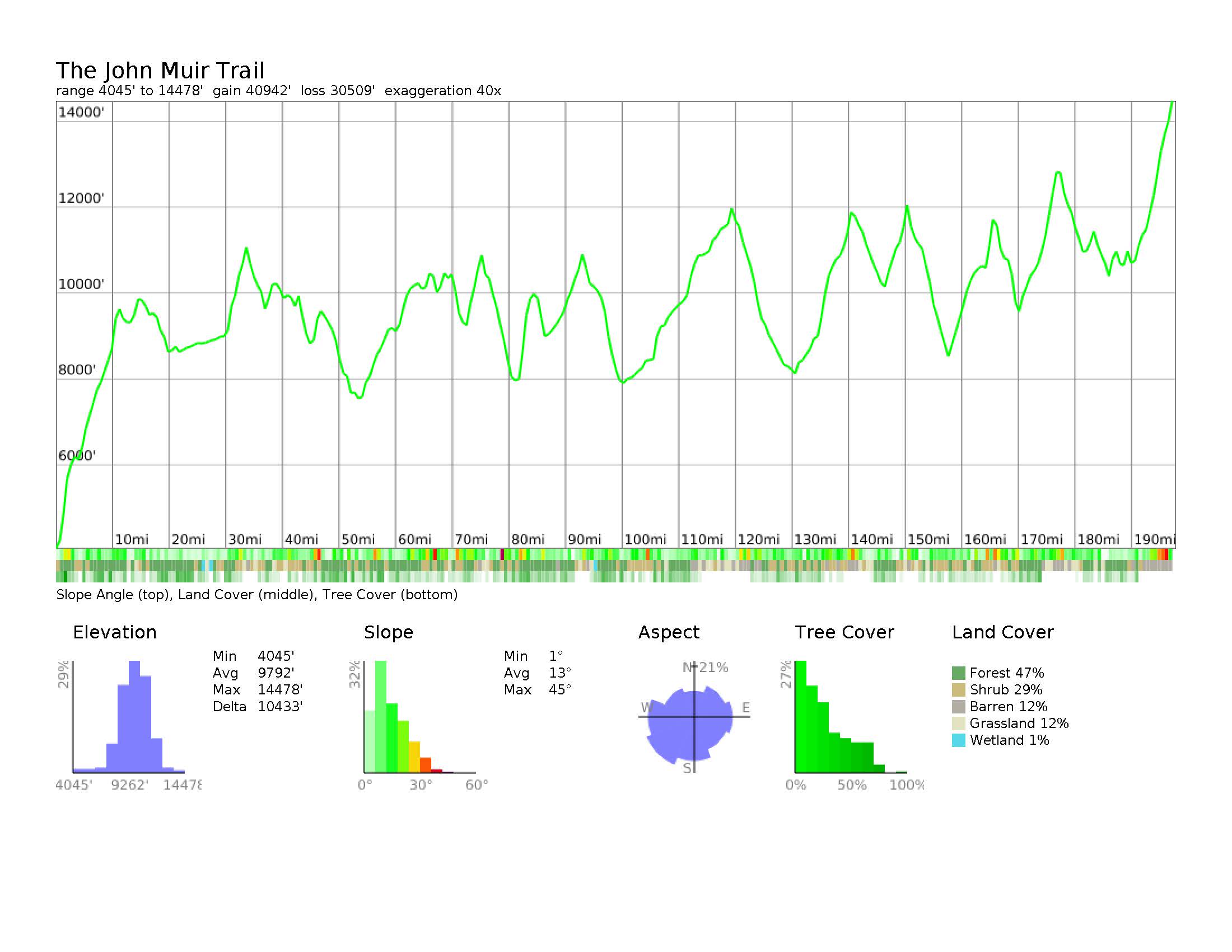
 John Muir Trail Profile